io.github.capan/isochrone
Berlin pedestrian isochrones: streets reachable on foot in N minutes (walk/stroller/wheelchair).
isochrone


Live: iso.huseyincapan.dev
Click anywhere on the map and see the street network you can actually reach on foot within 15 minutes — coloured by arrival time, with mobility profiles that account for stairs and unpaved paths.
OSM data → PostGIS + pgRouting → Express → Leaflet.
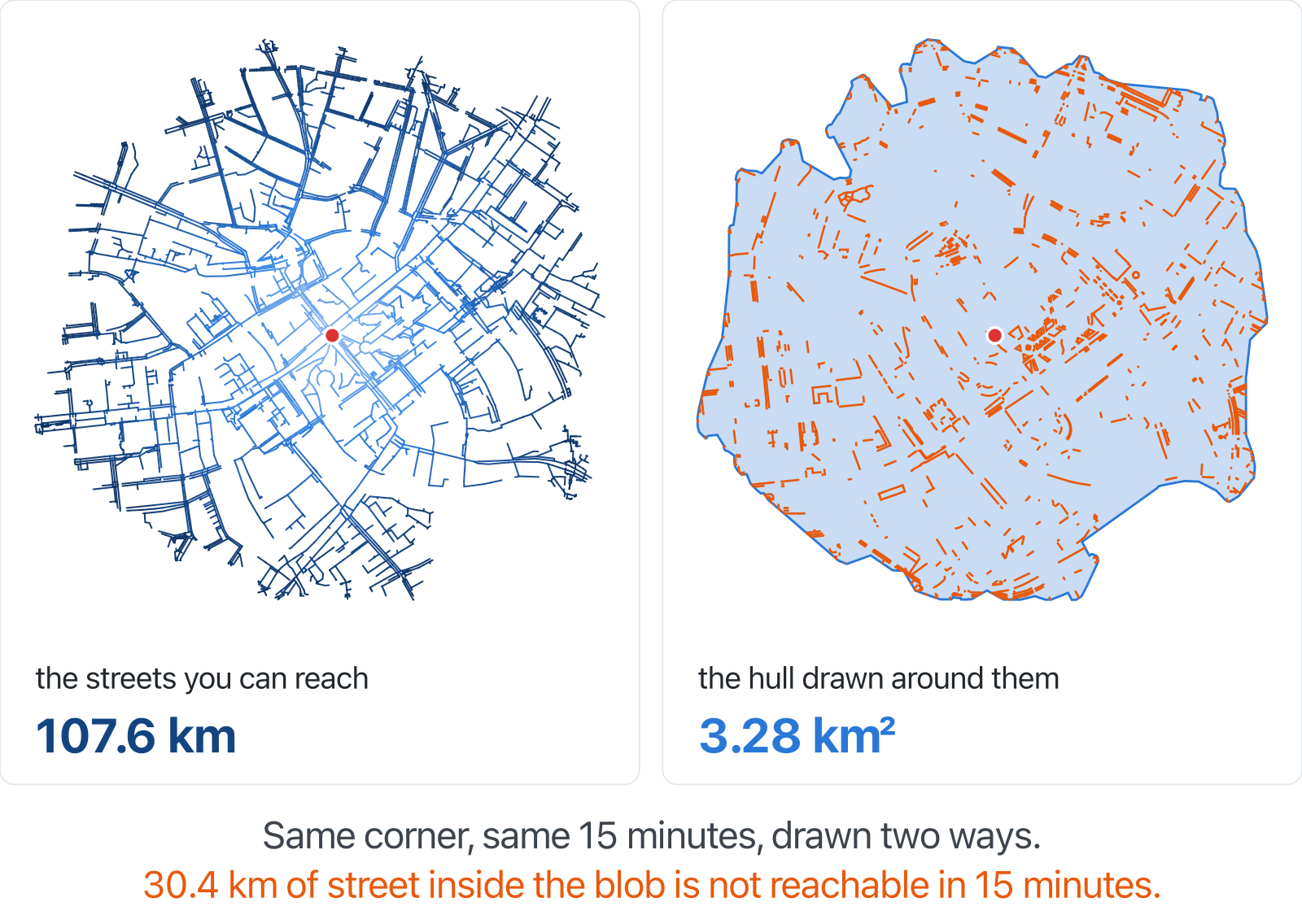
Why not a polygon?
Every isochrone map I could find answers with a filled polygon. That is wrong unless you are a pigeon: a polygon claims you can reach the middle of a block, cross a rail cutting, walk through a building. On the corner above, the same 15 minutes gives you 107.6 km of reachable streets; the hull drawn around them covers 3.28 km² and claims 30.4 km of street the walk cannot actually reach. This map draws the network.
How it works
pgr_drivingDistance walks the street graph from the vertex nearest your click
until the time budget runs out, and returns every reachable edge with its
arrival time. Those edges are grouped into 10 equal time bands and drawn
directly.
Edge cost is length / speed in seconds, computed per request from the
selected profile, so a profile is a few numbers rather than a schema change:
| profile | speed | stairs | unpaved |
|---|---|---|---|
walk | 1.4 m/s | half speed | normal |
stroller | 1.2 m/s | impassable | 0.6× |
wheelchair | 0.9 m/s | impassable | impassable |
These factors are estimates, not measurements — see Known gaps.
Where should I live?
Answer a short questionnaire weighting seven everyday layers (dining, green space, playgrounds, groceries, health, kindergartens, schools) and the whole Berlin map re-ranks to show where your weighted 15-minute city actually is, as walk, bike or wheelchair.
The trick is that nothing is routed at question time: 21 full-city reachability surfaces (7 layers × 3 profiles, ~134,000 grid cells each) are precomputed offline, so re-ranking the city is one aggregate query. Stroller is deliberately absent here: its speed factors are uncalibrated estimates and must not be published as if measured.
Ask Claude about it (MCP)
The isochrone-mcp package lets
any MCP client answer reachability questions against this API:
claude mcp add isochrone -- npx -y isochrone-mcp

One tool, reachable_area: origin + minutes + profile, optional target
("can I get there in time?"). Returns a prose summary and a map link, not
coordinate soup. Details in mcp/.
Known gaps
- Graph islands. The vertex nearest a click can sit on a disconnected
fragment —
52.515,13.400reaches 13 nodes. Fix is a one-timepgr_connectedComponentstable for the vertex lookup to join against. - Calibration. The speeds above are guesses. Google's Isochrones API
(Preview) supports
WALKand returns GeoJSON, so thewalkprofile could be calibrated against it. It has no stroller/wheelchair mode, so those stay unvalidated. - Stranded origins render as a tiny blob rather than saying "unreachable with this profile".
Running it yourself
Dev setup, deployment, city import and the ops notes live in docs/OPERATIONS.md.
Installation
Source-derived launch command. Check the maintainer’s required arguments and credentials before running:
npx -y isochrone-mcpSet up in your AI client
Merge this template into ~/Library/Application Support/Claude/claude_desktop_config.json. Keep existing servers. Add any arguments, credentials, and permissions required by the maintainer; this template has not been install-tested.
{
  "mcpServers": {
    "io-github-capan-isochrone": {
      "command": "npx",
      "args": [
        "-y",
        "isochrone-mcp"
      ]
    }
  }
}
Restart Claude Desktop completely for changes to take effect. Confirm the server appears connected in the client’s tool list, then try a read-only example from its documentation.
Claude Desktop setup referencePackage
isochrone-mcpnpmCompatible MCP Clients
io.github.capan/isochrone works with any MCP-compatible client. Copy the config snippet from the Configuration section above and add it to the file shown for your client, then restart the application.
- Claude Desktop
~/Library/Application Support/Claude/claude_desktop_config.jsonRestart Claude Desktop completely for changes to take effect. - Cursor
~/.cursor/mcp.jsonRestart Cursor for changes to take effect. - VS Code
.vscode/mcp.jsonReload VS Code window for changes to take effect. - Windsurf
~/.codeium/windsurf/mcp_config.jsonRestart Windsurf for changes to take effect. - Claude Code
.mcp.jsonSave at the project root, then start Claude Code in that project and review the MCP server approval prompt. Keep real credentials out of shared files.